Japan has exactly three roads that are 100 meters (328 feet) wide. Start crossing at a crosswalk, and you might not reach the other side before the light turns red. These aren't highways or freeways; they're urban boulevards running through the heart of major cities. How did such enormous roads come to exist, and why only three? The answer lies in the ashes of World War II.
Why "100 Meters"? Japan's Radical Post-War Urban Experiment
By the end of World War II in 1945, Japan's major cities were in ruins. Nagoya, a key military manufacturing hub, had lost roughly 24% of its total area to firebombing, with central districts like Naka and Higashi wards seeing 50–60% destruction. Hiroshima, of course, was devastated by the atomic bomb.
In December 1945, the Japanese government adopted the "War-Damaged Areas Reconstruction Plan," which included an ambitious idea: constructing roads 50 to 100 meters wide in major cities across the country. These super-wide roads would serve three purposes, as firebreaks to stop the spread of fires, as evacuation spaces during disasters, and as infrastructure for a future automobile-based society.
The original plan called for up to 24 such roads across seven cities: Tokyo, Kawasaki, Yokohama, Nagoya, Osaka, Kobe, and Hiroshima. But that grand vision would soon be drastically scaled back.
Nagoya Moved First: The Vision of Tabuchi Juro
The driving force behind Nagoya's 100-meter roads was a civil engineer named Tabuchi Juro. As the city's chief engineer, Tabuchi presented a reconstruction plan at the first postwar emergency city council meeting in September 1945, just one month after Japan's surrender. While the council initially approved 11 roads at 50 meters wide, Tabuchi pushed for something bolder: two additional roads at a full 100 meters.
When Nagoya presented this plan to the national government, officials were stunned by the 100-meter figure. So why that specific width? According to a Ministry of Construction official involved at the time, the reason was surprisingly simple: "because 100 is a nice round number." In an era with no traffic flow studies or computer models, this massive urban design decision was made largely on intuition and engineering judgment.
On December 6, 1945, Nagoya publicly announced its "Greater Chukyo Reconstruction Vision" in local newspapers, weeks before the national government finalized its own reconstruction guidelines late that same month. Nagoya had in fact set up its municipal reconstruction committee back in October, moving ahead of the national timetable. This head start would prove crucial.
The plan faced fierce opposition from citizens. "Are you building an airstrip?" some demanded. Others protested the forced relocation of 279 temple graveyards across the city into a single consolidated cemetery, known today as Heiwa Park. But Tabuchi and city leaders persisted through years of persuasion.
One factor that made Nagoya's 100-meter roads feasible was the city's historic grid layout. The "Kiyosu-goshi", the organized grid of approximately 100-meter square blocks established by Tokugawa Ieyasu in the early 1600s, meant that one entire block could be converted into a road without disrupting adjacent blocks. The Edo-period urban planning, laid waste by wartime bombing, inadvertently provided the perfect template for a radical modern transformation.
The "Dodge Line": From 24 Roads to Just 3
In 1949, American banker Joseph Dodge arrived in Japan and prescribed severe austerity measures to combat inflation. This policy, known as the "Dodge Line," slashed government spending dramatically, including funding for reconstruction projects.
One by one, the planned 100-meter roads across Japan were abandoned. Cities that hadn't moved quickly enough simply couldn't secure the budget. In the end, only three roads were completed: Nagoya's north-south Hisaya-odori and east-west Wakamiya-odori, plus Hiroshima's Peace Boulevard (Heiwa-odori).
A popular myth claims that GHQ (the Allied occupation authority) explicitly blocked the 100-meter road plans, declaring that "a defeated nation doesn't need grand roads." However, historians suggest this was more likely a convenient excuse used by local officials who wanted to abandon the costly projects and needed a powerful-sounding reason to satisfy residents.
Hiroshima's Peace Boulevard: Born from Atomic Devastation
Hiroshima's 100-meter road has an especially poignant origin. In late 1944, as the Pacific War intensified, the military ordered "building evacuation" (tatemono sokai) in Hiroshima, the forced demolition of homes and structures to create firebreaks against anticipated air raids. Citizens, including mobilized middle school students and members of the National Volunteer Corps, were conscripted to tear down buildings and clear the land.
On August 6, 1945, while thousands of civilians and students were still working on these evacuation sites, the atomic bomb was dropped. An estimated several thousand people, many of them young students, perished at the very locations that would later become Peace Boulevard. The road's 100-meter width is literally built upon one of history's most devastating tragedies.
After the war, the 1946 "Hiroshima Reconstruction Urban Plan" incorporated this evacuation land into a 100-meter road as a centerpiece, alongside Peace Memorial Park and riverside greenbelts. The road was conceived as a "symbol of peace and postwar recovery." Even when the Dodge Line cut budgets elsewhere, Hiroshima received priority treatment, and Peace Boulevard was fully completed in 1965.
The name "Peace Boulevard" was chosen through a public naming contest. A 1950 city planning document describes it as "a thoroughfare that gathers the hearts seeking peace toward Peace Park."
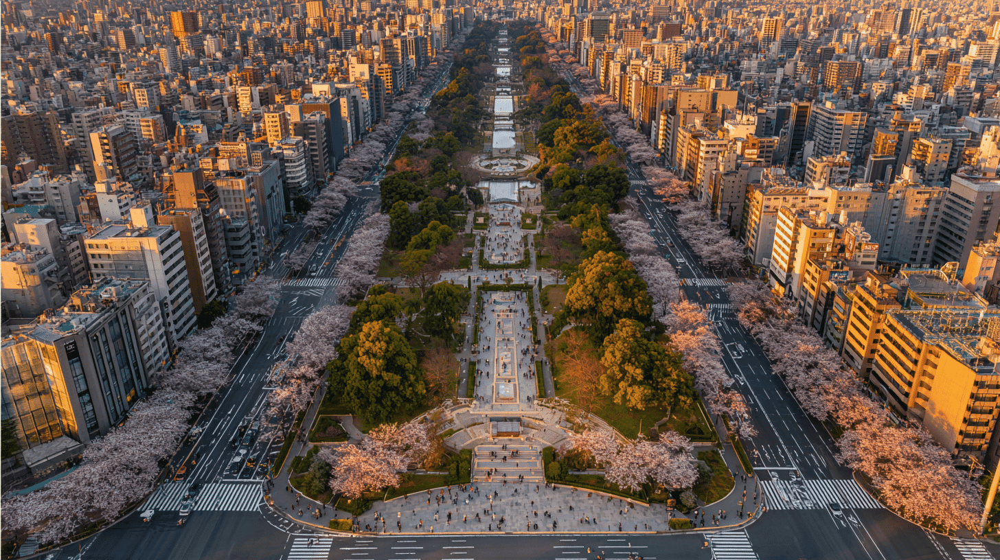
The Three 100-Meter Roads Today
Hisaya-odori (Nagoya, North-South)
Stretching 1.7 km with an average width of 112 meters, Hisaya-odori's 70-meter-wide central median has been transformed into Hisaya-odori Park. In 2020, the northern section was redeveloped as "Hisaya-odori Park", a mixed-use space blending retail, dining, and green space. At its center stands the Nagoya TV Tower (now Chubu Electric Power MIRAI TOWER), built in 1954 as Japan's first multi-purpose broadcasting tower and designated a National Important Cultural Property in 2022. Hisaya-odori has a sister-road agreement with Paris's Champs-Élysées and is listed among Japan's Top 100 Roads. Fully opened in 1963.
Wakamiya-odori (Nagoya, East-West)
Running approximately 4 km, this eight-lane road (four lanes in each direction) features a 51-meter-wide central park that includes tennis courts, futsal courts, basketball hoops, and even a skating rink, facilities you'd never expect to find in a road's median strip. The Nagoya Expressway Route 2 (Higashiyama Line) runs on an elevated structure above the park. Named after the nearby Wakamiya Hachimansha shrine. Fully opened in 1964.
Peace Boulevard (Hiroshima, East-West)
Also approximately 4 km long, Peace Boulevard has a different layout from its Nagoya counterparts. Rather than a central park flanked by roads, it features a central four-lane roadway with green belts on both sides and additional service roads on the outer edges. The green spaces contain over 150 species of trees, many donated through a nationwide tree-giving campaign (kyoboku undo) that drew contributions from across Japan and overseas. Every May during Golden Week, the Hiroshima Flower Festival fills the boulevard with over 1.5 million visitors. Fully opened in 1965.
What Makes These Three "100-Meter Roads" Special?
Other roads in Japan technically exceed 100 meters in width. Sapporo's Odori Park has been roughly 105 meters wide since the Meiji era. Tokyo's National Route 357 along the bay reaches about 100 meters. A section of Osaka's Chuo Loop Line exceeds 122 meters.
So why are "Japan's 100-meter roads" said to number only three? The distinction lies in their origin and purpose. These three were specifically planned and built as part of post-WWII reconstruction policy, designed as combined firebreaks, evacuation zones, and urban green boulevards (boulevards). Simply being 100 meters wide doesn't earn the title. It's the wartime destruction, the postwar vision, and the deliberate planning that set these three roads apart.
What began as firebreaks designed to prevent future catastrophic fires has evolved into urban oases: green corridors, cultural venues, and gathering places loved by residents and visitors alike.
The boldness of imagining 100-meter-wide boulevards in a nation barely emerging from total war, and the persistence required to overcome fierce public opposition, makes these roads remarkable not just as engineering feats but as statements of resilience and forward thinking.
Does your country have roads, buildings, or public spaces that were born from the aftermath of war or disaster? We'd love to hear about the landmarks of resilience in your part of the world.


Global Discussion
16 comments